
VOLCANIC RISK MANAGEMENT (II): Actions before, during, and after a volcanic crisis
BEFORE AN ERUPTION: RESEARCH, MONITOR, PLAN, AND COMMUNICATE
During volcanic rest periods, prevention and preparedness strategies are implemented that are essential to increasing capacity and reducing the vulnerability and exposure of communities living in or near an active volcanic area. Therefore, volcanic risk management before a volcanic crisis must focus on several key aspects. Here are some of them:
- Continuous research and monitoring
The nature of eruptive phenomena is very complex and, even with a robust monitoring network and real-time information, understanding and interpreting recorded signals and making accurate forecasts requires expanding scientific knowledge. For this reason, continuous study of volcanic areas considered active is necessary to understand the evolution and current state of the volcano or volcanic system. What types of eruptions have occurred in the past? When and how often did they occur? How large were they and what impact did they have? These are some of the questions that need to be answered through volcanological research, which requires experts in geology, mathematics, physics, and chemistry, among others. One of the outcomes of this research is volcanic hazard maps, which show the areas that could be affected by different hazards, such as ash fall or lava flows (Figure 1).
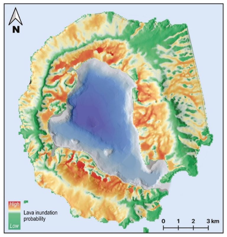
Figure 1. Example of a probability map of lava flow inundation on Deception Island (Antarctica). Modified from Bartolini et al. (2014) in Bolós et al. (2024).
In addition to understanding the evolution of the volcano, it is necessary to define its baseline activity level (for example, some volcanoes emit gases continuously without this indicating an imminent eruption) and to improve the detection and interpretation of precursor signals prior to an eruption (for example, ground deformation or seismic activity). This requires a clear commitment to comprehensive monitoring networks equipped with advanced systems that, as we learned in the volcano monitoring blog, allow accurate assessment of the state of volcanic activity and its evolution (Figure 2).
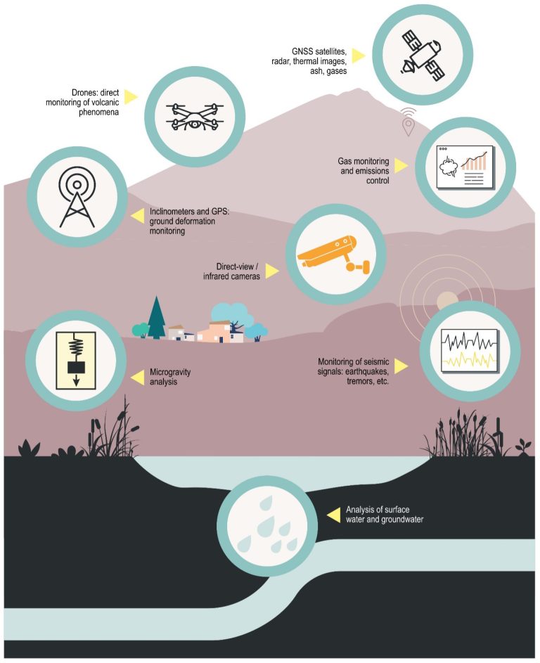
Figure 2. Visual summary of the main volcano monitoring and surveillance techniques. Modified from Bolós et al. (2024).
2. Land-use planning, safe construction, and emergency plans
Another key aspect during the volcanic repose phase is land-use planning and safe construction. Based on volcanic hazard maps and vulnerability studies, high-, medium-, and low-risk zones are defined, allowing for land-use planning that reduces unnecessary exposure to danger.
Before an eruption occurs, it is also necessary to define emergency plans that detail the actions to be taken in the event of a volcanic crisis, who is responsible, what evacuation routes to follow, etc. These emergency plans also establish different volcanic alert levels according to the volcano’s activity. In volcanology, a color-coded system similar to a traffic light is often used: the lowest level is green, the highest is red, and the intermediate levels are yellow and orange. Defining these levels and the criteria for changing between them is a complex process that varies depending on the country or volcanic area. In the Canary Islands, the Plan Especial de Protección Civil y Atención de Emergencias por riesgo volcánico en la Comunidad Autónoma de Canarias (PEVOLCA) follows this four-color scheme, known as the ‘volcanic traffic light’, with indications about the volcano’s activity and the actions to be taken by the authorities (Figure 3).
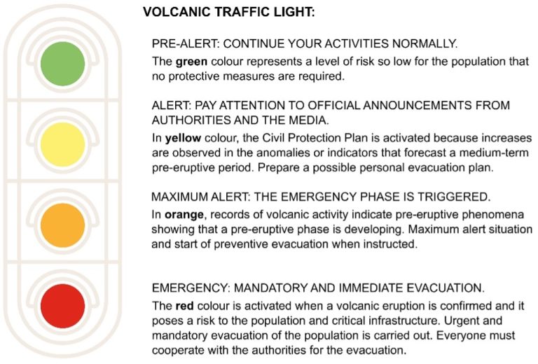
Figure 3. Volcanic traffic light from the Plan Especial de Protección Civil y Atención de Emergencias por riesgo volcánico en la Comunidad Autónoma de Canarias (PEVOLCA) to communicate the alert level. Modified from Bolós et al. (2024).
3. Early education, perception, and training
Education and public awareness also play a key role in the phase prior to a volcanic crisis. At-risk communities must understand the hazards they are exposed to and be prepared to respond appropriately if an event occurs. They must also be familiar with emergency protocols, evacuation routes, and early warning systems. This is why significant investment is needed in training and educational materials to improve early education and the preparedness of exposed communities, reducing their vulnerability and strengthening their response capacity (Figure 4). It is also important to conduct evacuation drills to improve the speed and coordination of response by communities and emergency and civil protection services during a volcanic crisis.
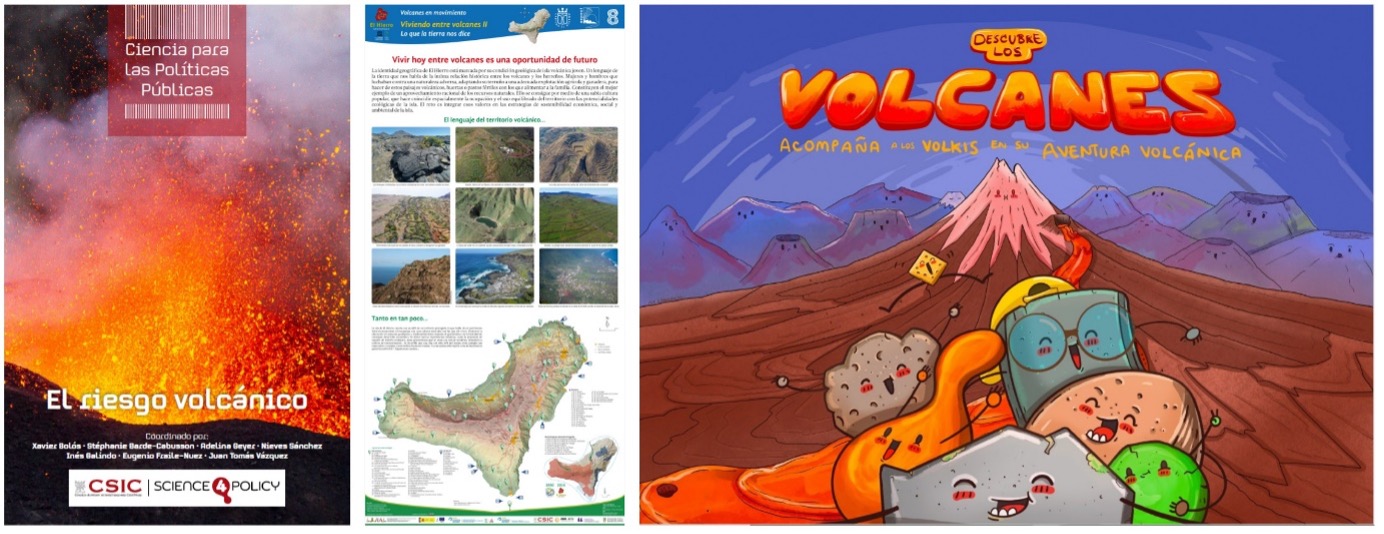
Figure 4. Examples of educational material to improve early education and public understanding of the environment. Left: cover of the report “Volcanic risk”, part of the “ Science for Public Policy ” series by the Spanish National Research Council (Bolós et al., 2024). Centre: example of a panel from the “Volcanoes in motion” initiative, aimed at promoting awareness of the geological history and volcanic environment of El Hierro and La Palma islands (Perez-Torrado et al., 2022). Right: cover of the book developed by the “Discover volcanoes” initiative, where the Volkis take readers on a fascinating journey through the world of volcanoes, their hazards, and benefits (Schamuells et al., 2022).
DURING AN ERUPTION: MONITOR, ASSESS, AND DECIDE
When a volcano erupts, decision-making must be swift and based on scientific evidence. From the start of an eruption, monitoring and tracking volcanic activity are essential to advise the authorities responsible for managing the event about its evolution and expected hazards. It is crucial to reinforce the monitoring network and activate scientific committees to evaluate and interpret the large volume of data collected by the system. In the specific case of the Canary Islands, this committee is known as the Comité Científico de Evaluación y Seguimiento de Fenómenos Volcánicos (CCES), stablished under PEVOLCA. This Scientific Committee advises the Emergency Management Body by interpreting the signals recorded by the monitoring networks, assessing the volcanic activity, and determining the most likely scenarios. To do so, it relies on data collected during the emergency and compares it with information of previous studies conducted in the area.
Based on the information provided by the Scientific Committee, government bodies and decision-makers establish the volcanic alert level, manage official communications, and activate the necessary measures. Depending on the alert level, these actions can range from simple preventive monitoring to the mandatory evacuation of certain areas, depending on the evolution of the phenomenon (Figure 5).
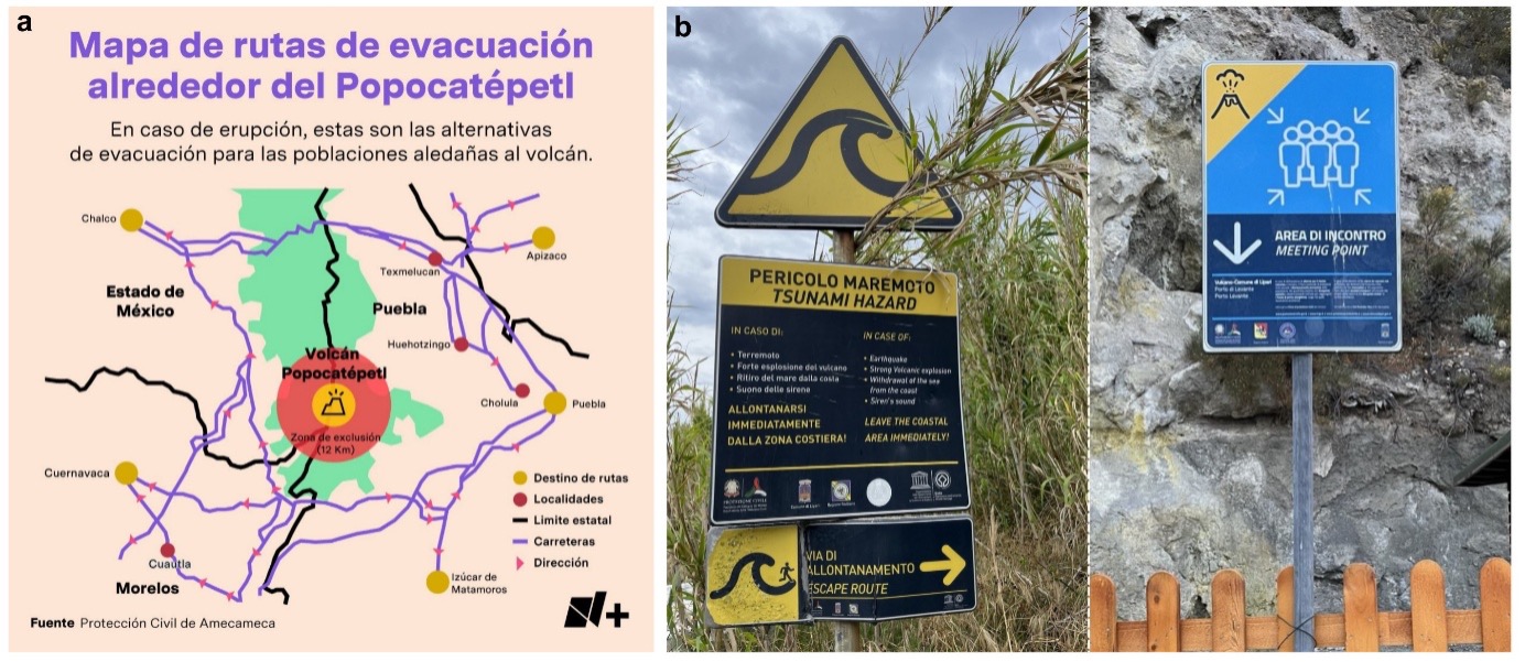
Figure 5. a. Infographic distributed to the public on evacuation routes in the event of an eruption of Popocatépetl volcano (Mexico); Civil Protection of Amecameca (https://amecameca.gob.mx/). b. Examples of signage to inform the public about routes and meeting points in case of evacuation due to volcanic risk in Stromboli (left) and Vulcano (right), Aeolian Islands; photographs by Claudia Prieto-Torrell.
During the management of an ongoing volcanic eruption, evacuating the population is one of the most complex decisions. While leaving a risk zone can save lives, it also presents significant challenges. The mass displacement of people can cause logistical problems, difficulties in the supply of food and medical services, and economic strain on the affected communities. In addition, social uprooting, the possible loss of homes, and the disruption of access to livelihoods (for example, jobs or farmland) can lead to resistance from residents, making evacuation efforts more difficult. Other factors, such as a lack of trust in the authorities, emotional and cultural attachment to the land, fear of looting, economic hardship, or the perception that the risk is not imminent, further complicate the situation. Therefore, it is essential to establish effective communication strategies to ensure that the population understands the seriousness of the situation and acts accordingly. Misinformation or panic can worsen the situation, so official communication channels must provide constant updates based on scientific data.
AFTER AN ERUPTION: MONITORING, ADAPTATION, AND RECOVERY
A volcanic crisis does not end when the eruption stops. In many cases, hazards such as toxic gas emissions, unstable terrain, or large quantities of ash can persist for months or even years. The post-eruption phase is therefore a critical period in which the need to return to normalcy must be balanced with public safety (Figure 6).
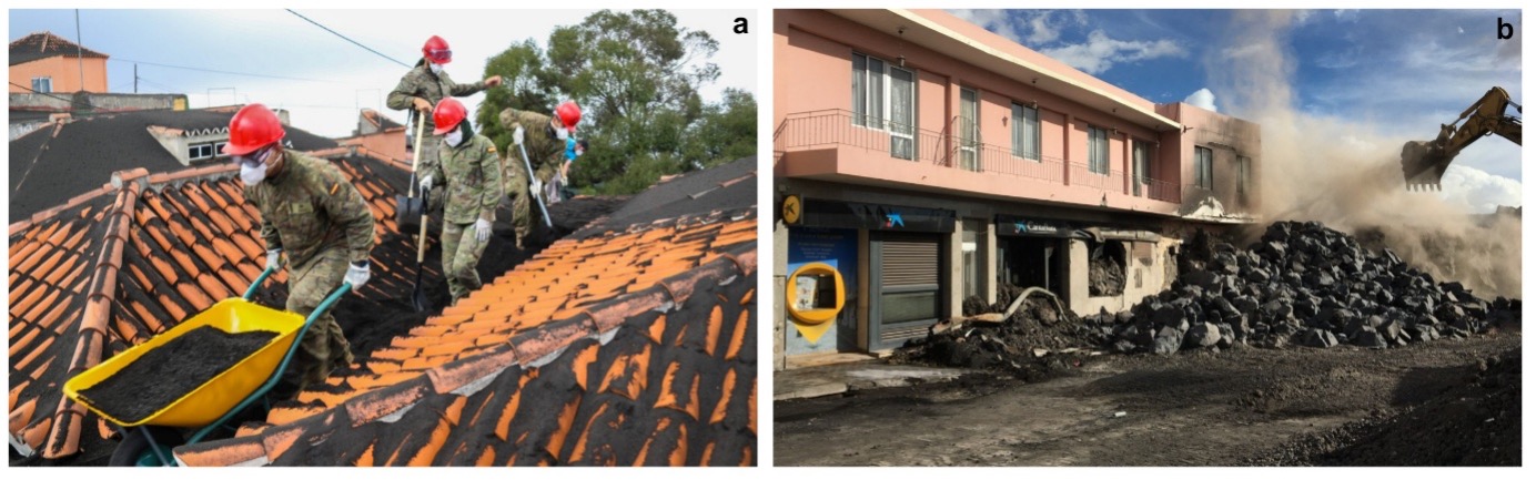
Figure 6. Examples of recovery in towns affected by the 2021 eruption in La Palma. a. Ash removal from rooftops in the town of Las Manchas, carried out using personal protective equipment such as helmets, goggles, and masks; Unidad Militar de Emergencias (UME). b. Lava removal using an excavator in the town of El Paso, as part of the works to reopen affected communication routes; photograph by Claudia Prieto-Torrell.
One of the first steps in this stage is assessing the eruption’s impact. This includes quantifying material damage, environmental effects, and socio-economic consequences. Based on this assessment, recovery plans should be designed to prioritize rebuilding critical infrastructure, restoring basic services, and supporting displaced populations.
Adaptation is also a key aspect. In some cases, it may be necessary to relocate entire communities if the terrain is no longer safe. This requires coordinated efforts between governments and civil society to ensure a fair and effective transition.
Volcanic risk management presents complex challenges and requires collaboration among various scientific disciplines, authorities, and civil society. The key lies in prevention, strategic planning, and efficient response capacity to minimize the impact of these natural phenomena. Through research, education, and international cooperation, it is possible to significantly reduce the risks associated with volcanic activity and improve the resilience of exposed communities (that is, their ability to adapt, overcome, and recover quickly from difficult or crisis situations).
References
Bartolini, S., Geyer, A., Martí, J., Pedrazzi, D., Aguirre-Díaz, G., 2014. Volcanic hazard on Deception Island (South Shetland Islands, Antarctica). J. Volcanol. Geotherm. Res. 285, 150–168. https://doi.org/10.1016/j.jvolgeores.2014.08.009
Bolós, X., Barde-Cabusson, S., Geyer, A., Sánchez, N., Galindo, I., Fraile-Nuez, E., Vázquez, J.T., 2024. El riesgo volcánico. Editorial CSIC, Ciencias para las Políticas Públicas. http://doi.org/10.20350/DIGITALCSIC/16384
Perez-Torrado, F.J., Rodriguez-Gonzalez, A., Moreno-Medina, C.J., Cabrera, M.C., Carracedo, J.C., Díaz-Rodríguez, S., Fernandez-Turiel, J.L., Criado, C., Aulinas, M., Prieto-Torrell, C., 2022. Volcanes en movimiento: El Hierro y La Palma. DIGITAL.CSIC. https://doi.org/10.20350/digitalCSIC/14494
Schamuells, N., Geyer, A., Aulinas, M., Dorado, O., Hopfenblatt, J., Martí, J., 2022. Descubre los volcanes: Acompaña a los Volkis en su aventura volcánica (v.1.1). Zenodo. https://doi.org/10.5281/zenodo.6320151
If you want to cite this entry from the volkiblog:
Prieto-Torrell, C., Geyer, A., Bolós, X., Barde-Cabusson, S., & Schamuells, N. (2025). VOLCANIC RISK MANAGEMENT (II): Actions before, during, and after a volcanic crisis. Zenodo. https://doi.org/10.5281/zenodo.16780909
Texts: Claudia Prieto-Torrell (GEO3BCN-CSIC), Adelina Geyer (GEO3BCN-CSIC), Xavier de Bolós (GEO3BCN-CSIC), Stephanie Barde-Cabusson (GEO3BCN-CSIC)
Illustrations: Noah Schamuells (GEO3BCN-CSIC)
Terms of use: This document is published under a CC By-NC-ND (Creative Commons Attribution-NonComercial-NoDerivates) license. Downloading and sharing is allowed freely as long as proper credit is given. It may not be changed in any way or used commercially. For more information about the CC By-NC-ND click here.