
Geological evolution of La Palma
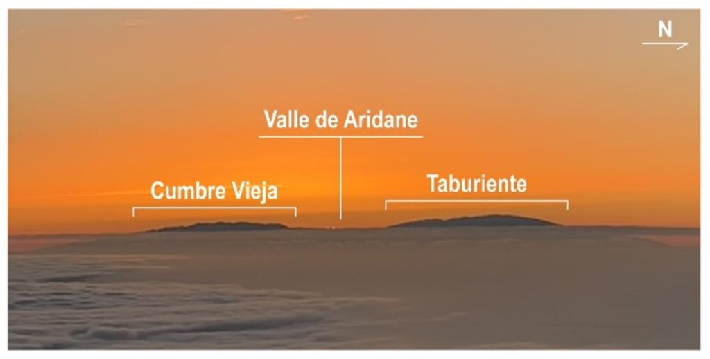
Figure 1. Panoramic view towards the east of La Palma, taken from Tenerife, showing the Taburiente and Cumbre Vieja edifices separated by the Valle de Aridane; photograph by Claudia Prieto-Torrell.
Taburiente and Cumbre Vieja are not, however, the only volcanic edifices that have shaped the island’s landscape. In fact, the geological history of La Palma, like that of any oceanic volcanic island, begins… at the seabed!
Around 4 million years ago, the effusive activity began to slowly raise a submarine seamount in what we know today as La Palma. The onset of the deep submarine growth was marked by the formation of poorly vesiculated pillow lavas due to the water pressure being too high for the gases to separate from the magma (Figure 2a).
Over time, the continuous accumulation of volcanic (lava and domes) and plutonic (gabbros) material allowed the submarine edifice to gain height, getting ever closer to the sea surface. During this stage of shallow submarine growth, the explosive activity dominated due to the interaction at shallow depths between magma and water, resulting in the formation of highly vesiculated pillow lavas and explosive breccias, product of surtseyan eruptions (Figure 2b).
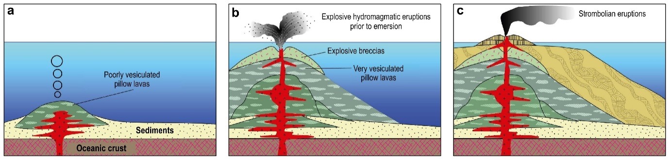
Figure 2. Sketch illustrating the onset of the deep submarine growth 4 million years ago (a), the shallow submarine growth (b), and the subaerial growth of La Palma approximately 1.77 million years ago (c). Modified from Perez-Torrado et al. (2022).
Finally, around 1.77 million years ago, the summit of the submarine volcanic edifice emerged above the surface, marking the birth of La Palma as an island (Figure 2c). The first 500,000 years of La Palma’s subaerial history were marked by intense volcanic activity in what is nowadays the northern part of the island. Successive eruptions, mostly strombolian, led to the accumulation of pahoehoe lavas and deposits of scoriaand lapilli, forming the Garafía volcanic edifice (Figure 3a), which reached heights between 2,500 and 3,000 meters above sea level.
The rapid and unstable growth of the Garafía volcano was interrupted about 1.2 million years ago, when a giant landslide caused the collapse of its southern flank (Figure 3b). From then on, the following eruptions built the Taburiente volcanic edifice, characterised by thick horizontal lavas that were progressively ponded against the Garafía landslide scar (Figure 3c). In the southern part of the Taburiente volcano, a very high (over 2,500 meters) and unstable ridge known as Cumbre Nueva developed, which collapsed westwards about 560,000 years ago, forming the Valle de Aridane. This second collapse is known as the Taburiente landslide (Figure 3d).
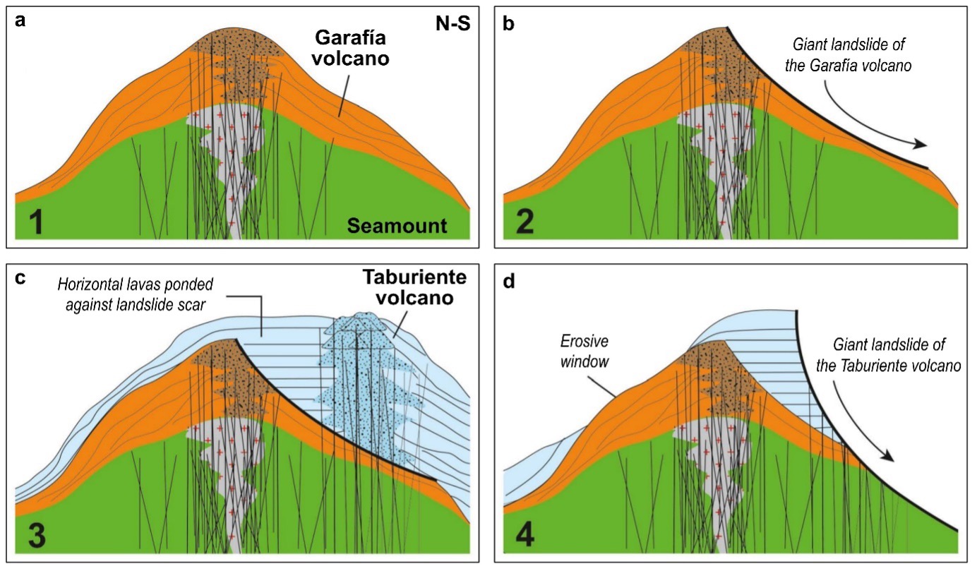
Figure 3. Sketch illustrating the subaerial geological evolution of northern La Palma island, including the development of the Garafía volcanic edifice (a), the Garafía giant landslide (b), the development of the Taburiente volcanic edifice (c), and the Taburiente giant landslide (d). Modified from Perez-Torrado et al. (2022).
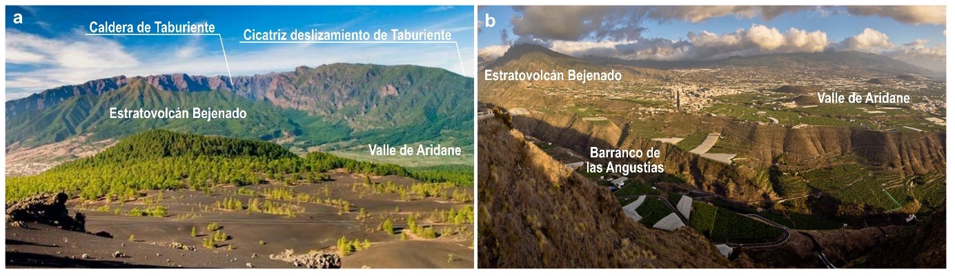
After the Taburiente landslide, the volcanic activity concentrated in the northern part of the Valle de Aridane, rapidly building the Bejenado stratovolcano about 490,000 years ago (Figure 4). Between this volcano and the Taburiente landslide scar, the Barranco de las Angustias was also formed, representing a deep incision in the terrain that channels water from the island’s centre toward its western edge (Figures 4 and 5). The water erosion and the collapse of parts of its slopes created the impressive Caldera de Taburiente (Figures 4 and 5a), which is not a volcanic caldera sensu stricto but a massive depression formed by fluvial erosion, surrounded by high cliffs and considered one of La Palma’s most iconic landscapes.
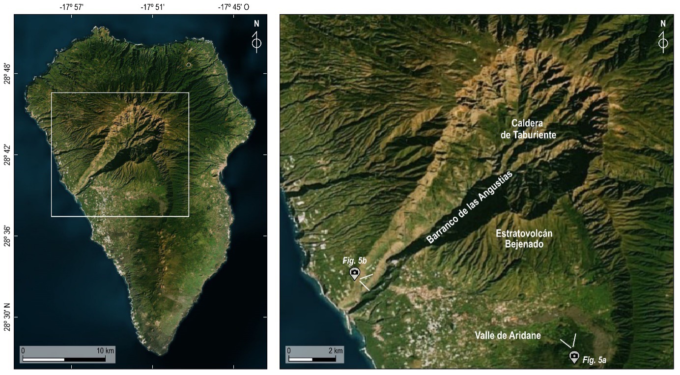
Figure 4. Aerial view of La Palma (left) and detail of the Caldera de Taburiente, the Barranco de las Angustias, the Bejenado stratovolcano, and the Valle de Aridane (right). Modified from ESRI® Satellite.
Indeed, inside the Caldera de Taburiente, we can observe remnants of rocks from the submarine stage, such as pillow lavas (Figure 6), and from Garafía, the first volcanic edifice of the subaerial stage. But… how is it possible that rocks formed on the ocean floor are nowadays exposed on the surface of La Palma? This is due to a combination of volcanic and tectonic processes, along with water flow and erosion in the Barranco de las Angustias, which have uplifted and tilted these rocks within the Caldera.
Indeed, inside the Caldera de Taburiente, we can observe remnants of rocks from the submarine stage, such as pillow lavas (Figure 6), and from Garafía, the first volcanic edifice of the subaerial stage. But… how is it possible that rocks formed on the ocean floor are nowadays exposed on the surface of La Palma? This is due to a combination of volcanic and tectonic processes, along with water flow and erosion in the Barranco de las Angustias, which have uplifted and tilted these rocks within the Caldera.
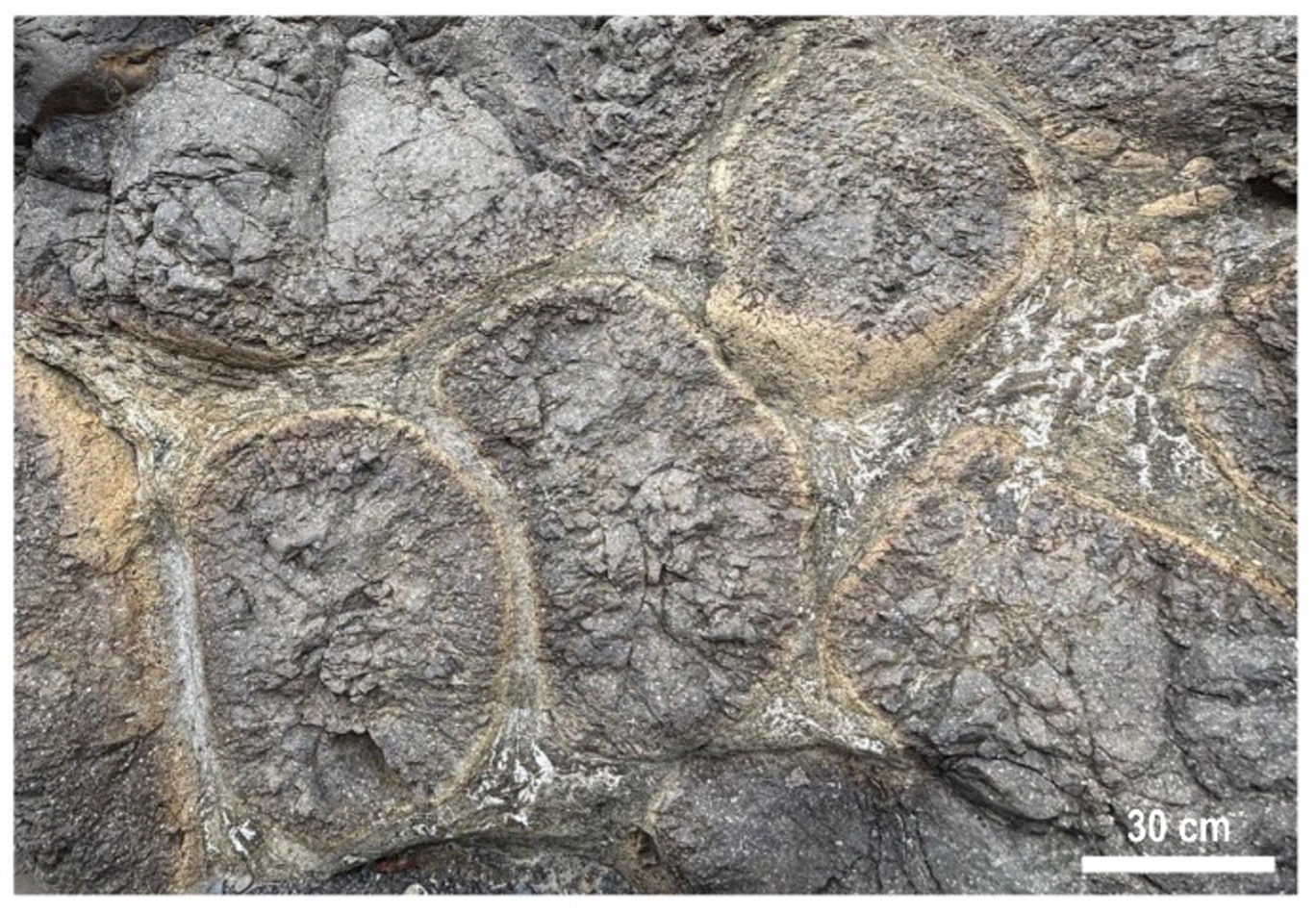
Figure 6. Pillow lavas formed during the submarine growth stage, exposed within the Barranco de las Angustias; photograph by Adelina Geyer.
The volcanic activity in the northern part of the island continued until about 400,000 years ago. After a period of relative “eruptive calm”, the southern part of La Palma became the focus of new eruptions around 150,000 years ago. Gradually, a high (1,950 metres) and elongated (20 kilometres) structure, known as the Cumbre Vieja ridge, was formed (Figure 7).
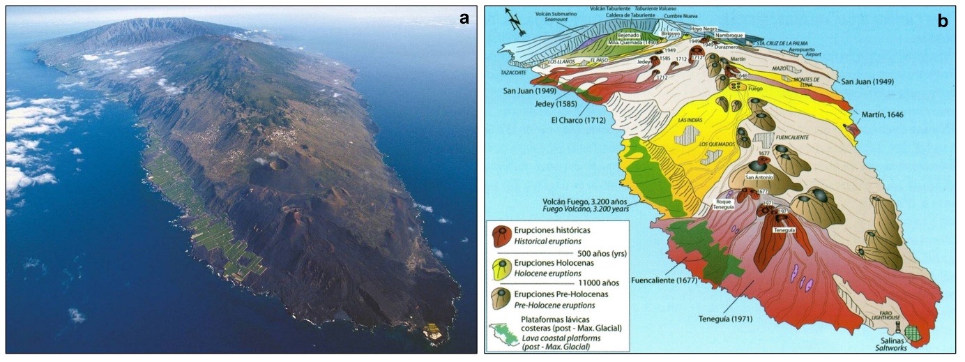
Figure 7. View towards the north of the Cumbre Vieja ridge; photograph by Sergio Socorro (a) and its geological sketch, including historical (last 500 years), Holocene (last 11,000 years), and pre-Holocene eruptions (more than 11,000 years ago); modified from Carracedo et al. (2001) (b).
Along the central axis of Cumbre Vieja, there are tens of monogenetic volcanic cones that have been accumulated, from which multiple lava flows have been emitted down to the east and west slopes of the ridge (Figure 7). Eruptions at Cumbre Vieja have been typically strombolian and phreatomagmatic, producing lava flows and scoria and lapilli deposits.
Cumbre Vieja is also responsible for all historical eruptions on La Palma (Figure 7b), such as those of Teneguía (1971) and Tajogaite (2021). This geological history demonstrates why La Palma is a spectacular example of how volcanism can build and transform a region over time. Today, its fertile soil supports rich vegetation, and its unique landscapes attract tourists and scientists from around the world eager to explore its lush forests, rugged coasts, and impressive volcanic rock formations. However, we know that volcanic activity continues to shape the island, reminding us that La Palma, like the rest of the Canary Islands, is a living and constantly evolving place.
References
Carracedo, J.C., Rodriguez-Badiola, E., Guillou, H., de La Nuez, J., Perez-Torrado, F.J., 2001. Geology and volcanology of La Palma and El Hierro, Western Canaries. Estud. Geol. 57, 175-273.
Perez-Torrado, F.J., Rodriguez-Gonzalez, A., Moreno-Medina, C.J., Cabrera, M.C., Carracedo, J.C., Díaz-Rodríguez, S., Fernandez-Turiel, J.L., Criado, C., Aulinas, M., Prieto-Torrell, C., 2022. Volcanes en movimiento: El Hierro y La Palma. DIGITAL.CSIC. https://doi.org/10.20350/digitalCSIC/14494
Prieto-Torrell, C., Geyer, A., Aulinas, M., & Schamuells, N. (2025). Geological evolution of La Palma. Zenodo. https://doi.org/10.5281/zenodo.14737459
Texts: Claudia Prieto-Torrell (GEO3BCN-CSIC), Adelina Geyer (GEO3BCN-CSIC), Meritxell Aulinas (UB)
Illustrations: Noah Schamuells (GEO3BCN-CSIC)
Terms of use: This document is published under a CC By-NC-ND (Creative Commons Attribution-NonComercial-NoDerivates) license. Downloading and sharing is allowed freely as long as proper credit is given. It may not be changed in any way or used commercially. For more information about the CC By-NC-ND click here.